


VTD-precinct 3, Sanborn County, South Dakota
About
Outline

Summary
| Unique Area Identifier | 667761 |
| Name | VTD-precinct 3 |
| County | Sanborn County |
| State | South Dakota |
| Area (square miles) | 71.92 |
| Land Area (square miles) | 71.88 |
| Water Area (square miles) | 0.04 |
| % of Land Area | 99.94 |
| % of Water Area | 0.06 |
| Latitude of the Internal Point | 44.02167750 |
| Longtitude of the Internal Point | -98.14541110 |
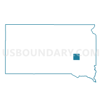
Maps

Graphs
Select a template below for downloading or customizing gragh for VTD-precinct 3, Sanborn County, South Dakota


Neighbors
Neighoring Voting District (by Name) Neighboring Voting District on the Map
- VTD-precinct 1, Sanborn County, SD
- VTD-precinct 2, Sanborn County, SD
- VTD-precinct 4, Sanborn County, SD
- VTD-precinct 5, Sanborn County, SD
Top 10 Neighboring County Subdivision (by Population) Neighboring County Subdivision on the Map
- Butler township, Sanborn County, SD (247)
- Woonsocket township, Sanborn County, SD (149)
- Logan township, Sanborn County, SD (133)
- Letcher township, Sanborn County, SD (120)
- Elliott township, Sanborn County, SD (99)
- Silver Creek township, Sanborn County, SD (92)
- Twin Lake township, Sanborn County, SD (86)
- Jackson township, Sanborn County, SD (78)
- Union township, Sanborn County, SD (63)
- Warren township, Sanborn County, SD (60)